23. Hole in the Wall to Bulungula River Mouth
07 May 2023


IMAGES
23. Hole in the Wall to Bulungula River Mouth
07 May 2023
some of the hardest beauty i have ever seen...
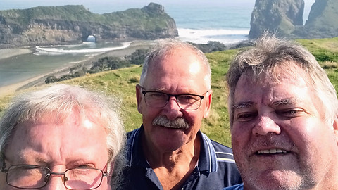
This hike was organized at very short notice when I received a call from Andre Freitag and Johnny van Heerden—two school friends—who were already on the road to spend a week at Hole in the Wall. Andre lives in Bloemfontein, and Johnny had sold his cottage at Hole in the Wall a year earlier and moved to Rustenburg. Johnny had arranged free accommodation through a friend named Brian, and they invited me to join them. I immediately accepted on the condition that they assist me with transport for a hike I had been planning from Hole in the Wall to Bulungula. The call came at about 09:00 on the 5th of May 2023. It felt as though the universe was perhaps conspiring with me as I sought to finish this walk - saying yes to opportunities as they presented themselves was starting to feel important!
At 10:00, I left Port Elizabeth, with Cath still coming to terms with my sudden decision and not informing work about taking a few days off. This trip was completely unplanned. In Peddie, I had to stop for fuel, and in Komga, I grabbed a case of beers, brandy for Johnny, rum for Andre, mixers, and plenty of ice. By the time I reached Viegiesville, I stopped again for fuel and a sandwich, as I had not eaten all day. It was getting dark quickly, and I drove the last 10 km with the full moon rising from the sea. I stopped to take a photo, as the moon brought a calmness to my mind after a rushed, unplanned day. The moon had played a pivotal role in the lives of my two sons and me. From their toddler years, I always reminded them that even when we were apart, we were still connected through the moon. If they could see it, they knew I was looking at the same moon, sharing thoughts in that moment.
Upon arrival, the moon cast a bright silver path over the sea. The fire was burning high, and my friends greeted me with beers in hand. True, spontaneous friendship over 50 years is priceless, and in that moment, I felt immense gratitude. For many of us, some of what we built on these early years had washed away - but these foundations remained. We strolled down to a wooden deck overlooking the beach, appreciating the beauty of the surroundings while the soft sound of lazy waves played in the background. After a lovely braai, we spent the next day sightseeing around the Big Hole, inspecting Johnny's old cottage (which was being renovated), and enjoying a late beach walk to gather driftwood for a bonfire. My plan was to begin my hike the next day, so we all went to bed around 22:00.
We woke up around 05:30, and while I packed my rucksack, Andre and Johnny insisted on making me breakfast before I set out. As I mentioned in a previous story about my hike between Hole in the Wall and Coffee Bay, I had already walked to Lubanzi Viewpoint with Hennie, where I was bitten by a dog on the ankle. The plan today was for Andre and Johnny to drive me to the same viewpoint, and from there, I would continue the coastal hike to Bulungula. They would then pick me up later and return me to Hole in the Wall in the afternoon. At 07:10, I was dropped off where the road ended (just past Zithulele Hospital heading toward the sea). After posing for a few photos, I began walking along a double vehicle track that led past a few huts and up the hill overlooking Lubanzi Beach, where Hennie and I had been before. I stopped at the same spot and filmed a video to send to Hennie, reminding him that he had wanted to do this hike with me, but he couldn’t make it due to work commitments.
The path steeply descended before crossing a small stream, leading me to Lubanzi. The trail then turned into a gravel road that passed an abandoned lifesaving building and ascended a hill, where the Lubanzi Backpackers site stood on the right. At the top of the hill, I switched to a footpath that led toward the sea. The path soon disappeared into thick bush, and I found myself scrambling down a rocky gully to a stream. I managed to cross, then climbed a slippery bank to an open sand mining area, where the walking became easier. I soon found a road leading to Mpolompo Point, a famous fishing spot. However, not wanting to return up the hill, I stayed on higher ground, following the ridge of the hill.
At 08:40, I was rewarded with a view of "paradise." Below me lay a long beach; to my left, dense bush and trees; and to my right, the Mncwasa River, flowing from inland. The descent was steep, but I found a footpath that led through the bush onto the beach. I sat on a tree stump just before 09:00, removed my shoes, and packed my cell phone in a Tupperware container before crossing the fast-flowing river at waist height. This river is impassable at high tide, so thankfully I was prepared. On the other side, the landscape changed—no more beach, but over a kilometer of rocks stretching into the sea. This area is known as Mpame Fishing Spot, and I saw several fishermen working the rocks with their 4x4 vehicles parked nearby. The ground was very wet from recent rains, and in places, my entire shoe sank into the mud. Two black fishermen caught up with me and mentioned that Mpame Beach and the "Bulls Inn" accommodation were not far, but around a steep, rocky point ahead. One fisherman watched from below as I slowly navigated my way down and around the point to the beautiful Mpame Beach. I took a photo of the beach, with cottages visible in the distance. The route around the point cannot be done at high tide, and the alternative is a lengthy 4x4 track used by fishermen.
At 10:00, I reached "Bulls Inn" and was amazed to see sheep drinking saltwater from the small river leading to the beach.
I didn’t stop, as I had enough water, and was racing against the rising tide. I followed the gravel road up a winding hill, pausing to look back at the beach and the rocks I had just climbed. This coastline is truly unspoiled, as shown in my photos. The gravel road split to the right just over the hill, but I stayed on the road along the coast. After a few more hills, I could see the road heading inland. I asked a local man for directions, and he told me there was a footpath leading to Bulungula via "Kuamanzimnama" (meaning "black water" in Xhosa). I followed the gravel road to Mpame School, then turned left toward the sea. The footpath was overgrown and hard to follow, but I continued, tripping over my feet several times. At one point, I fell so hard that both my drink bottles fell from my rucksack. I took a moment to rest and snapped a photo of the tall grass that kept catching my feet with every step. There was no visible path, but I pressed on, heading toward the sea on a ridge above dense forest. Eventually, I reached the end of the ridge, where one of the most breathtaking coastal views I’ve ever seen awaited.
At 11:52, I filmed a video and took a photo of the view but wasn’t sure how to cross the deep ravine and scale the mountain on the other side. I was now far from civilization, and turning back wasn’t an option. I cautiously made my way down the hill, finding a distinct, washed-away path at the very edge, dangerously close to the sea below. Anyone with a fear of heights would not be able to walk here. It took me nearly 30 minutes to carefully descend to the bottom. Luckily, it was still low tide, and I was able to cross the "Black Water" river. I rested among the boulders before starting the steep climb up the hill. My legs were exhausted from the intense uphill struggles, and I must have stopped 10 times to rest. Each time, I looked back to motivate myself by remembering the "impossible" terrain I had conquered an hour earlier. I took videos and photos during the climb, unaware that many more hills lay ahead.
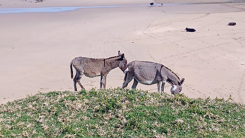
At 13:00, I finally saw Bulungula in the distance, but another gorge lay ahead before I could step onto flat beach sand again. This part was through long grass, with no visible path, but it was mostly downhill. I crossed two deep mudslides before reaching the beach. Two donkeys greeted me as I arrived. I was now beyond tired, and my legs, ankles, and feet ached with every step. At 13:30, I simply couldn’t go any further and decided to lie flat on my back to relieve the pressure on my muscles and joints. Fifteen minutes later, I stood up, filmed a video of myself talking about my exhaustion but also my gratitude. I was safe, out of the isolation, and past the unforgiving terrain. In the last three hours, I hadn’t seen any other humans or animals, except for the donkeys.
I still had 2 km of beach left to walk. I contacted Johnny and knew they were waiting for me at Bulungula. The tide was rising, and I walked on soft sand until I finally reached the Bulungula River at 14:20. I put down my rucksack and filmed a video for my friend Leon Hechter, who had camped there many times as a child. (He had asked me to send him a photo of the river mouth before the hike.) In the video, you can hear the wind picking up, and I mention how the river had swollen with the rising tide. The same washed-up tree from my earlier notes would later become significant when I walked from Xhora Mouth to Bulungula six months later, and three birds were sitting on that tree in the middle of the river.
However, my ordeal wasn’t over. I still had to cross the river to join my friends, who would take me home. I was 2-3 hours late, thanks to the slow pace and many rests. With the tide rushing in and the wind blowing toward the sea, walking through wasn’t an option. I packed my phone into Tupperware and, with great effort, swam "doggy style" while holding my precious walking stick in one hand. (I’ve since learned to tie the stick to my rucksack, allowing me to use both hands to swim more effectively - these are the things we learn only by first doing it sub-optimally to begin with) Finally, I made it across the river and had to catch my breath before climbing up the steep sandbank. Again, I was blessed with the presence of two of my best friends, a cold beer, and after 37,365 steps, I could proudly tick off another section of my coastal walk as done.