32. Old Woman’s River Mouth to Fish River Mouth
18 October 2024
the real plan reveals itself only when we stop insisting on our own plan
i didn’t try to beat nature - i simply re-negotiated my terms
danger teaches us clarity - but first it will need to show us our fear
i kept putting myself in danger
i couldnt help it
i keep circling this fear
i keep circling this


IMAGES
32. Old Woman's River to Fish River Mouth
18 October 2024
it all goes bust - but i don't
"The cave you fear to enter holds the treasure you seek.” - Joseph Campbell
On a previous hike from Begha River Mouth to Fish River Mouth (Chapter 14 - 17 August 2019), I stopped at Old Woman’s River to rest and overnight. However, unbeknown to me, I had set off a silent alarm system when I entered some empty rundown buildings on a sand dune. It had been raining softly and I was looking for shelter to stay dry.
I did not know it was part of the Fishriver Sun Hotel property until a security guard in a vehicle approached and told me I could not stay there. He would not give me permission to overnight there and I was forced to walk across the golf course to the hotel and make an overnight booking (in the Hotel itself).
I did not have the money, or a way to pay for it, and phoned Cathy to meet me at the entrance gate (which she did after a long drive from Port Alfred). Now, years later, I decided to complete that beach walk from those buildings again, along Waterloo Beach, around the famous Gibraltar Rock, and finally along the Fish River bank all the way to the N2 bridge.
It seemed as it was all coming together - as I connected these dots - these fragments of attention - like the time I thought to myself: “the shortest way home is seldom the straightest” and I wrote that down somewhere and it lived in my head - forever half collected - until I really stopped - and took the time to properly connect these dots.
At 06:38, a school friend, Hennie Deetlefs, dropped me off at the Fish River Hotel entrance and took a photo of me. The road was closed and blocked off with big rocks placed across it. There was no guard and I walked along the road with overgrown gardens on either side, past an abandoned guardhouse and gate boom all the way to the hotel building.
There was not a soul in sight as I followed the fairways of the 18th, 17th and 16th holes towards the sea. It was heartbreaking to see the beautiful golf course so overgrown and the greens and bunkers all destroyed. How the structures collapse even as the memory remains. I will never forget those fairways, and the many times I walked with my boys there - alongside. Some paths only reveal themselves when the fairways no longer even exist.
I crossed the wooden bridge and followed the path to the buildings where the security guard prevented me from staying overnight previously.
It took me an hour to cross the long grass of the golf course and at 07:41am I stepped onto the beach at Old Woman’s River. It was an overcast day with little wind, but luckily no rain. I took photos of the open beach to the east and the view towards the west with Gibraltar Rock in the distance.
The tide was retreating and walking was easy on hard beach sand and flat rocks. I found a washed-up tree at Waterloo Beach that was the perfect height to sit on comfortably. I took the time to have some “breakfast snacks” and cooldrink.
I sat there alone on this beautiful historic beach (Anglo Boer War campsite and graveyard of many British soldiers) reflecting on my life and those who were also far from home — who perhaps also looked at the sea, the huge Gibraltar Rock, and the thick bush-covered dunes. So many had been here before. So many had tried to connect their own dots in so many many ways - some ran at their death with greater fury than me - but we were all bloody terrified for most of it.
However, I was there by my own choosing, filled with peace and reflecting on the beauty around me, very different from most - reasons for gratitude, and the invitation of peaceful participation.
The sea had eroded the dunes and exposed the tree roots as the ground had collapsed and washed into the sea. At 08:10 I reached the sheer rock face of Gibraltar Corner and was disappointed to find the two metal signposts broken.
A footpath ran all along the cliff but then disappeared behind a bush that grew across the path about 10 meters from the signs. Furthermore, the path was above a hollow cliff and it was too dangerous for me to walk along it.
I chose to rather walk (sometimes on all fours) up a steep dune on the right of the signs as I knew the Fish River was on the other side of the hill. (I could not walk around Gibraltar Corner as the high rocks ran deep into the sea.) It was difficult on the soft sand and with every step the sand covered my entire foot and filled my shoe and sock.
Halfway up the dune I took a photo of the beach below while catching my breath. Soon I was on top, but horrified that the sand pathway had suddenly disappeared into thick high bush. I had been trapped in similar bush on previous hikes and realised I had just arrived at another dead end.
I still could not see the landscape of the river from where I was standing and took my time to survey all possible routes to the other side of the hill.
Finally, I saw a footprint of an animal in the sand and followed that into the bush. The bush was not as dense walking towards the corner of Gibraltar entering the sea, and after about five meters I actually found a footpath (must be a part of the one that I was too scared to walk on top of the hollowed rock face earlier).
This path led to the high cliffs above the river far below. It was 08:30 when I took a video of my surroundings and wondered how I was ever going to get down those cliffs as I had planned.
I followed the path along the cliff and about 500 meters further it dropped sharply into a valley. It was the only path in the thick bush, so I continued walking and soon found a very steep uneven (volcano rock) path in the bush that overlooked the river below.
I could see the top of what looked like a ladder at the bottom and instantly knew it must be a chain ladder leading down from the cliff. I very slowly made my way down the sharp uneven rocks only to find a very unstable ladder with only 3 steps. It was not secured and two plastic cooldrink bottles were pushed between the ladder and the bank to fill a gap and stabilize the structure. My biggest challenge was to balance on the uneven rocks, turn around, and crawl backwards on my knees to finally place one leg over the edge to the highest step, hoping the ladder would not slip away under my weight. (I had removed my walking stick over the edge but kept my rucksack on my back.) I was afraid as I could not see a thing and had to depend entirely on what I could feel — scary because of all the things I have been most afraid of - my feelings surely rank near the top of that list. Back to the action: first by balancing and holding onto thick branches, then with one foot on the ladder testing its stability, and finally lowering my weight onto it, I was able to find my way. Caution keeps you alive. Curiosity keeps you moving. It felt almost insane and impossible. Once committed, I had both feet on the edge and my balance depended entirely on my feet and the ladder. The ladder was very wobbly and with only three steps every movement was slow and cautious. There is something that seems to hold me when I risk with courage rather than fear.
Finally, at 08:40, I was on the beach alongside the river and started walking towards the bridge about a kilometer away. It was spring low tide and walking was easy on the sand — until I went around the corner and saw there was no pathway.
As mentioned before, it was spring low tide and I stopped to take a video of the speed of the outgoing current, the draining river, and the very uneven section of rocks. These rocks were covered in soft slippery mud or black algae, and each step was taken with caution. Falling and injuring myself would be a serious problem, as I was still far from my destination and this route is only possible due to the low tide. The bridge came into sight and I used it as a beacon of motivation — with every small slow step I was getting closer. Eventually the rocks stopped and turned into grassy swamp land. A path became visible again and led all the way towards a caravan park that came into sight.
Finally, I crossed another small slippery metal bridge with a yellow rope as a handrail before stepping onto a perfect gravel road in the caravan park. This last section along the river was the shortest yet took the longest (a full hour to cover a kilometer), but I was grateful that I survived the wet, slippery terrain without falling.
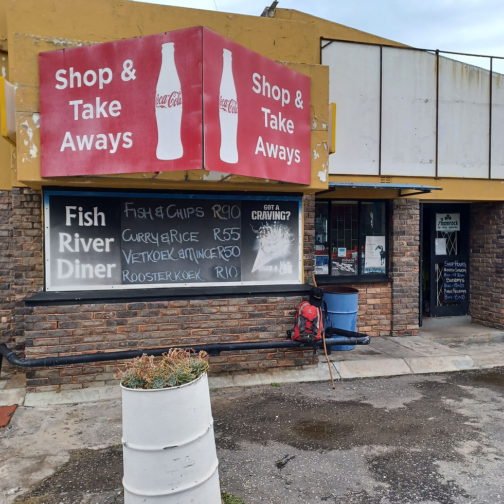
At last, at 09:25, I reached the “Fish River Diner” where a previous hike from Port Alfred had ended in April 2012 (Chapter 12) — and I could now connect the outstanding section around Gibraltar Rock to Old Woman’s River via the coastline (not via the golf course when the security officer had forced me to stop hiking). I came back. I walked it. No shortcuts. Not this time.


